
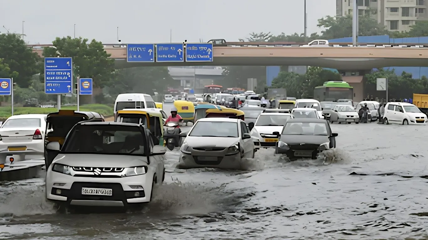
Noida and Ghaziabad also witness intense showers; waterlogging and traffic snarls reported across the region
New Delhi: The National Capital Region woke up to a major change in weather on Monday. After several days of sticky and uncomfortable heat, dark clouds covered the sky overnight and continued into the morning. Heavy clouds, thunder and long spells of rain hit Delhi, Noida, Ghaziabad and nearby areas. By mid-morning, heavy rain turned roads in several low-lying areas into shallow streams and slowed traffic on major roads. More importantly, the rain lowered temperatures and gave millions of residents a much-needed break from the high humidity of the past few days.
The India Meteorological Department (IMD) issued nowcasts around 11:10 a.m. and placed large parts of East Delhi and South Delhi under a red warning for heavy rain of more than 15 mm per hour. The warning also covered thunderstorms, lightning and strong winds of 30–40 km/h and remained valid until around 2:10 p.m. The IMD issued orange and yellow alerts for other parts of Delhi and NCR towns. Private weather forecasters also reported scattered intense rain cells over Ghaziabad, East Delhi, Noida and Gurugram during the same period.
What Is Happening on the Ground?
Residents in several Noida sectors, Indirapuram, Sahibabad, Vaishali and parts of East and South Delhi saw the sky suddenly turn dark before heavy rain began. Social media platforms quickly filled with pictures and videos of waterlogged underpasses, slow-moving traffic on the Delhi-Meerut Expressway and NH-9, and office-goers caught in the rain without umbrellas.
In some parts of Ghaziabad and Noida, intense rain caused temporary water accumulation on major roads. Delhi’s Safdarjung observatory recorded a minimum temperature of 27.8°C, around 1.4°C above normal, while the Ridge recorded a cooler 24°C. Daytime temperatures that had recently climbed into the mid-to-high 30s remained lower because of the rain and cloud cover. This brought noticeable relief from the sultry weather.
The rain did not continue without a break across all areas. Instead, several short but intense spells occurred, which often happens when active monsoon conditions create strong thunderstorms over the plains. Heavy rain also reduced visibility for short periods. Lightning prompted standard safety advice to stay indoors, avoid open areas and tall isolated trees, and stay away from metal structures.
Why Did the Weather Change So Suddenly?
Late-August weather in northwest India often depends on the position of the monsoon trough and the movement of moisture-filled winds. Residual western disturbances or low-pressure systems can also influence weather conditions.
This time, an active monsoon trough combined with moisture moving in from systems farther east. These conditions created a favourable environment for widespread thunderstorms and heavy rain. Thick clouds developed quickly and formed strong rain cells. These cells created the dramatic situation that made many residents feel as if the day had suddenly turned into night.
The NCR often experiences this type of active monsoon weather. Unlike the Northeast or the Western Ghats, which can receive continuous heavy rainfall for several days, the NCR usually gets short but intense bursts of rain. However, these heavy spells can still disrupt daily life because of the region’s dense construction, heavy traffic and drainage limitations.
Temperature and Humidity Bring the Biggest Relief
For many NCR residents, the biggest relief came not only from the rain but also from the fall in humidity.
Sultry weather occurs when high temperatures combine with high relative humidity. This combination makes people feel much hotter and more uncomfortable than the actual temperature suggests.
Monday morning’s rain and cloud cover reduced the potential for high daytime temperatures and lowered the humidity burden for some time. Humidity may rise again after the rain stops, but the temporary relief has already made a noticeable difference after several days of sticky weather.
District-Wise and Town-Wise Weather
- Delhi: East and South Delhi faced red-warning conditions for heavy rain, thunderstorms and lightning until the early afternoon. The city could receive several more rain spells during the day. Minimum temperatures remained close to normal or slightly above normal, while cloud cover kept maximum temperatures lower.
- Noida (Gautam Buddha Nagar): The city remained mostly cloudy and received very light to light rain during the morning. Another spell of light to moderate rain could occur during the afternoon and evening. Low-lying roads and underpasses face a risk of waterlogging.
- Ghaziabad: The city also saw cloudy skies and spells of light to moderate rain. Local reports indicated traffic problems and temporary water accumulation in several areas.
- Wider NCR (Gurugram, Faridabad): These areas also faced scattered thunderstorms and could receive short but heavy rain spells.
The IMD’s five-day district forecast for the NCR shows Monday as the most active day of the current spell. From Tuesday, the region should see partly cloudy skies with only a low chance of very light rain. Rainfall activity should decrease further during the rest of the week.
Will the Rain Continue?
The official forecast indicates that the NCR will gradually become drier after Monday.
Isolated light rain could still occur on Tuesday, but the broader forecast suggests mostly dry weather or only light showers after that. Temperatures will likely rise again as clouds move away. This means the current relief from the heat may remain temporary.
Residents should continue checking weather nowcasts because monsoon thunderstorms can produce intense rain in specific areas even when the overall weather remains relatively quiet.
Across northern and central India, several states continue to face heavy-rain alerts. Eastern Uttar Pradesh, parts of Bihar, Odisha, Chhattisgarh and the Himalayan foothills could receive heavier rainfall. The NCR currently sits on the western edge of the most intense weather activity.
Practical Advice for Commuters, Parents and Residents
- Check the latest IMD nowcast or the Mausam app before leaving home because weather alerts can change within a few hours.
- Keep extra travel time because heavy rain can cause waterlogging and slow traffic.
- Avoid underpasses and known low-lying areas during intense rainfall.
- Stay indoors during thunderstorms and keep away from windows when lightning becomes active.
- After heavy rain, take precautions against waterborne illnesses in areas that experienced prolonged waterlogging. Avoid walking through stagnant water whenever possible.
- People who work outdoors and children travelling to school should keep rain gear and an extra set of clothes ready for the next 24–48 hours.
The Bigger Monsoon Picture
India’s southwest monsoon remains active in late August. The current weather spell follows the broader pattern of intermittent heavy rain across the northern plains. The monsoon trough and moisture coming from the Bay of Bengal continue to drive this activity.
For the NCR, this pattern usually brings the kind of weather residents experienced on Monday: dark skies, sudden heavy showers, temporary relief from the heat and the usual problems caused by waterlogging and traffic.
The rain also offers some benefits. It can recharge groundwater and reduce peak temperatures, even if the relief lasts only for a short time.
As the afternoon progressed on 24 August, the heaviest rain cells were expected to weaken in many areas. However, light to moderate rain could continue in some places into the evening. From Tuesday, the region is expected to enter a quieter phase, with clouds gradually clearing and temperatures beginning to rise again.
For the millions of people living and working across Delhi, Noida and Ghaziabad, Monday’s weather brought a typical monsoon break — dramatic, disruptive and, for a few hours, a welcome escape from the sticky heat that had gripped the National Capital Region.
Residents should continue to follow official weather updates, travel carefully during rain and make the most of the cooler weather while it lasts.

Mansi Sharma is a journalist covering Global Affairs, and wellness, known for turning complex ideas into sharp, engaging narratives. Her work is driven by curiosity, depth, and a constant urge to question and explore. When she’s not writing, you’ll often find her diving into new ideas—preferably with a cup of coffee in hand, one sip at a time.