
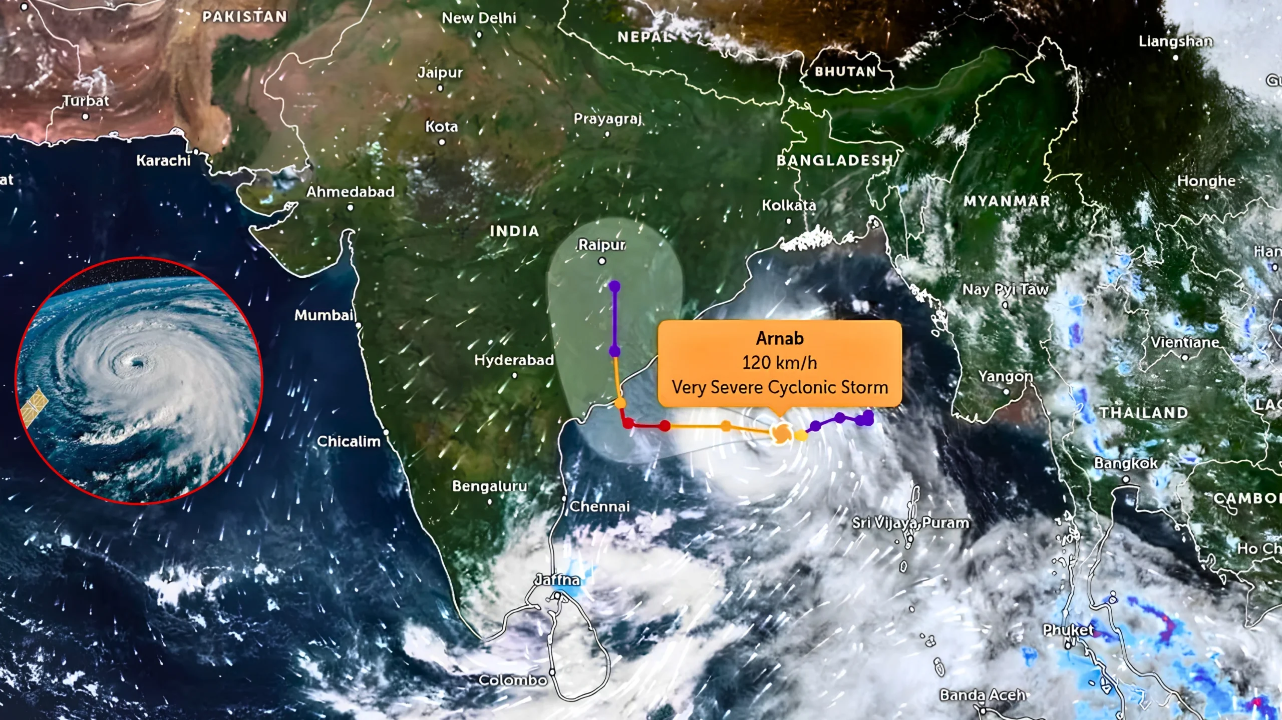
89,000 people evacuated, Red alert in 11 districts as very severe cyclonic storm packs 115-125 kmph winds and 1.5-metre storm surge near Yanam
NEW DELHI / VISAKHAPATNAM: Cyclone Arnab, a very severe cyclonic storm, is moving towards the Andhra Pradesh–Yanam coast with sustained winds of 115–125 kmph and gusts reaching 140 kmph. The storm is expected to make landfall by the forenoon of Wednesday, 28 October 2026.
Authorities have already closed schools across several coastal districts, cancelled dozens of trains, suspended fishing activities and started evacuating nearly 89,000 people from vulnerable areas. The storm has intensified over the west-central Bay of Bengal, raising concerns about heavy rainfall, strong winds and coastal flooding.
This report answers the major questions that residents and readers may have about the cyclone, including its origin, expected path, rainfall warnings, school closures, evacuation efforts, safety measures and the likely impact after landfall.
What Is Cyclone Arnab and How Did It Form?
Cyclone Arnab (pronounced “Ornab”) developed from a low-pressure area over the east-central and adjoining west-central Bay of Bengal. The system gradually strengthened into a deep depression and then a cyclonic storm on 26 October 2026.
By late Monday night and early Tuesday, the storm had intensified into a very severe cyclonic storm. Several favourable weather conditions supported its rapid growth. These included sea surface temperatures close to 30°C, strong upper-level outflow and a supportive phase of the Madden-Julian Oscillation.
Bangladesh contributed the name “Arnab” under the World Meteorological Organization’s regional naming list for cyclones over the North Indian Ocean.
Current Status and Intensity (As of the Morning of 27 October)
The India Meteorological Department (IMD) reported that Cyclone Arnab was moving west-northwestwards at around 22 kmph. The storm was located approximately 260–350 km southeast of Visakhapatnam and 300–420 km east-southeast of Kakinada.
The IMD has classified Arnab as a very severe cyclonic storm. It has maximum sustained winds of 115–125 kmph, with gusts reaching 140 kmph. Some international cyclone trackers had earlier reported peak winds close to the equivalent of a Category 2 hurricane. The central pressure has also dropped significantly, indicating that the storm has become more organised ahead of landfall.
Exact Landfall Forecast: Where and When Will Cyclone Arnab Hit?
Cyclone Arnab is expected to make landfall by the forenoon of Wednesday, 28 October 2026, along the Andhra Pradesh coast between Bapatla and Visakhapatnam, near Yanam, a Puducherry-administered enclave on the Andhra coast.
After crossing the coast as a very severe cyclonic storm, Arnab is expected to turn almost northward and gradually lose strength. The system may move through interior Andhra Pradesh, Telangana and Chhattisgarh before possibly reaching areas farther north. It will continue to bring rainfall as it moves inland.
The IMD has issued a Red Message cyclone warning for the Andhra Pradesh coast and adjoining parts of the south Odisha coast.
Rainfall, Wind and Storm Surge Warnings
Extremely heavy rainfall is expected across coastal Andhra Pradesh and Yanam on 27 and 28 October. Heavy to very heavy rainfall will also affect southern Odisha, eastern Telangana and parts of Chhattisgarh.
The IMD has issued red alerts for several Andhra Pradesh districts for the day of landfall. These include Anakapalle, Kakinada, Konaseema, East Godavari, West Godavari, Eluru, Visakhapatnam, Alluri Sitharama Raju, NTR, Krishna and Guntur. Orange and yellow alerts cover other coastal and neighbouring districts.
A storm surge of 1–1.5 metres above the normal astronomical tide may flood low-lying coastal areas. Officials expect the highest surge near East Godavari, including Kakinada, and Yanam.
Winds of 115–125 kmph, with gusts reaching 140 kmph, will affect areas near the landfall zone. These winds may damage thatched houses, uproot trees, bring down power lines and disrupt communication services. The sea will remain very high to phenomenal near the storm’s centre.
Schools and Colleges Closed: Full District List
Andhra Pradesh has declared holidays in at least 10 coastal and adjoining districts. These include:
- East Godavari
- Kakinada
- Dr B.R. Ambedkar Konaseema
- Krishna
- NTR
- Vizianagaram
- Visakhapatnam
- Eluru
- Anakapalli
- Polavaram
Most of these districts have closed schools for 27 and 28 October. Anakapalli has extended the holiday until 29 October. The closures cover schools under different managements.
Odisha has also ordered school closures in southern districts, including Ganjam, Gajapati, Rayagada, Koraput and Malkangiri. Some reports mention closures in six districts. Depending on the district, schools will remain closed on 27–28 October or 28–29 October.
Authorities in the Andaman and Nicobar Islands had also closed schools earlier as the weather system developed.
Transport Disruption: Trains Cancelled and Fishing Banned
South Coast Railway has cancelled 53 trains, while some reports put the total at 61. The cancellations affect services operating on 27 and 28 October along routes connecting Visakhapatnam, Vijayawada, Rajahmundry, Kakinada, Machilipatnam, Bhimavaram, Narasapur, Guntur and other stations.
Railway authorities have advised passengers to check official railway updates before travelling to avoid inconvenience.
Authorities have also suspended fishing activities along the Andhra Pradesh and Odisha coasts. They have directed fishermen not to venture into the Bay of Bengal until at least 29 October because the sea remains extremely rough to phenomenal.
Evacuations, Relief Camps and Government Response
Authorities in Andhra Pradesh are evacuating around 89,000 people from vulnerable coastal settlements. They have prepared approximately 101 relief camps with food, drinking water, medical supplies and other essential items.
The state government has sanctioned ₹27 crore for emergency relief operations across 20 districts. District collectors can use these funds to meet immediate requirements in affected areas.
Teams from the National Disaster Response Force (NDRF) and State Disaster Response Force (SDRF) are deployed for rescue and relief operations. The Army, Navy, Air Force and Coast Guard have placed rescue teams, ships and aircraft on standby. Authorities have closed beaches and tourist spots. Power utilities have also moved to high alert and prepared restoration teams and dewatering pumps to respond to emergencies.
The National Crisis Management Committee reviewed the preparedness measures under the leadership of the Cabinet Secretary. Andhra Pradesh Chief Minister N. Chandrababu Naidu directed officials to remain on high alert and closely monitor the situation.
Odisha has also mobilised hundreds of response teams. The state has cancelled holidays for agriculture officials working in affected areas to ensure that they remain available during the emergency.
Impact on Daily Life, Agriculture and Infrastructure
Heavy rainfall and storm surges pose a serious flooding risk to low-lying areas along the coast. Standing crops, particularly in coastal districts, may also suffer damage because of flooding, waterlogging and strong winds.
Residents in the main impact zone may face power cuts, fallen trees and temporary disruptions to road transport and communication networks.
The cyclone may also bring heavy to extremely heavy rainfall to interior districts of Telangana, particularly Khammam, Bhadradri Kothagudem and Mulugu. Parts of Chhattisgarh, Vidarbha and areas farther north may continue to receive rainfall as the storm weakens after landfall.
Safety Tips and Precautions for Residents
Residents in the affected areas should follow official instructions and take the necessary precautions before the storm reaches the coast.
- Follow updates and instructions from the IMD and state disaster management authorities.
- Move to designated relief camps if you live in a low-lying area or a thatched house that may not withstand strong winds.
- Keep essential medicines, drinking water, dry food, torches and power banks ready.
- Stay away from the sea, rivers and flooded roads.
- Secure loose items outside your home and remain indoors during periods of strong winds.
- Keep mobile phones fully charged and emergency contact numbers readily available.
- Never touch fallen electric wires or damaged electrical equipment.
- After the cyclone passes, wait for officials to issue an all-clear before returning home. Check your house for structural damage before entering.
Authorities in some areas are also moving pregnant women and vulnerable patients from coastal hospitals to safer locations as a precaution.
What Happens After Landfall?
Once Cyclone Arnab moves inland, it is expected to weaken into a cyclonic storm, then a deep depression and eventually a well-marked low-pressure area. The system will continue moving northward as it loses strength.
Heavy rainfall may continue over interior regions for another day or two after landfall. The system is expected to weaken further and eventually dissipate.
How to Stay Updated on Cyclone Arnab
Residents should monitor official sources for the latest warnings, evacuation instructions and transport updates. These include:
- India Meteorological Department (IMD): mausam.imd.gov.in and @Indiametdept
- State disaster management authorities: Andhra Pradesh and Odisha
- Local district administrations: Official alerts and emergency instructions
- Public broadcasters: All India Radio and Doordarshan updates
Cyclone Arnab highlights the risks that the Bay of Bengal’s active post-monsoon cyclone season can pose to coastal communities. Improved forecasting, early evacuations and coordination among multiple agencies have helped reduce loss of life in recent years compared with earlier decades.
Residents in the cyclone’s path should take all warnings seriously, complete their preparations in advance and avoid unnecessary outdoor activities as the storm approaches.
Stay safe and stay informed.

Mansi Sharma is a journalist covering Global Affairs, and wellness, known for turning complex ideas into sharp, engaging narratives. Her work is driven by curiosity, depth, and a constant urge to question and explore. When she’s not writing, you’ll often find her diving into new ideas—preferably with a cup of coffee in hand, one sip at a time.